

The nine members of the California Water Commission have been given a task: to decide how to award the $2.7 billion in Prop 1 funds slated for water storage; twelve projects have submitted applications. In order to be better informed prior to making the decision, the Commission has been hearing from panels of experts at its monthly meetings. In September, the panel title was 21st Century Infrastructure, and present to inform commission members were Kamyar Guivetchi from DWR Division of Statewide Integrated Water Management; Dave Bolland, ACWA’s Director of State Regulatory Operations; and Dr. Roger Bales, Director of UC Merced Sierra Nevada Research Institute.
Here’s what they had to say.
KAMYAR GUIVETCHI
Statewide Integrated Water Management Division Manager Kamyar Guivetchi discussed the System Reoperation Study and how it relates to other work underway by the state and others.
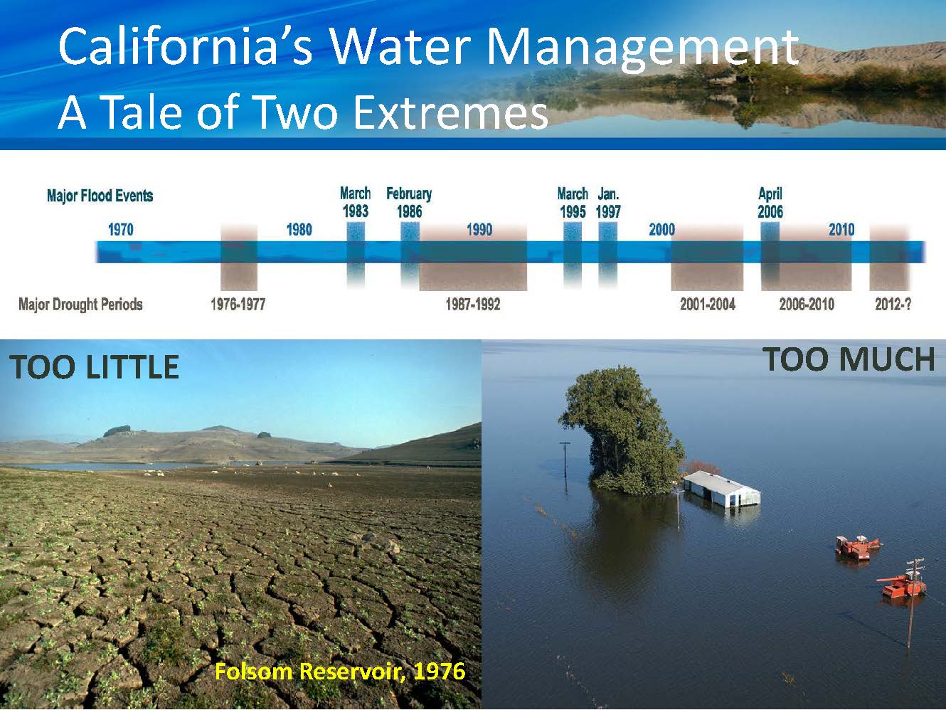 He began by reminding that California water is a tale of extremes: We get most of our rain in the winter; use a lot of water in the summertime. However, climate change and the tremendous growth and development that California has had is making the consequences of those extremes and the extremes themselves become more challenging than before. The recent five year drought is going to become a trend with California water and we have to change how we think about managing it, he said. The snowpack has been and still is our largest surface reservoir; that is changing and will continue to change as the snow is melting sooner in the year and the snowpack itself is forecasted to become quite diminished over the rest of the century.
The foundational theme of the 2018 California Water Plan Update is sustainable water resource management and taking an integrated and holistic approach for managing California water that involves flood management, water supply management, water quality management, and ecosystem management. “We have to begin managing these in an integrated way, so while our panel title is the Infrastructure for the 21st Century, we really need to have a water management institutional framework for the 21st century, because those infrastructure are managed and operated by a plethora of institutions that were set up to be very specialized and did not have an integrated approach in mind,” he said.


The water plan update will focus on defining what is really meant by sustainable water resource management in terms of outcomes and indicators. The Governor’s Water Action Plan calls for making the most efficient use of water and making water conservation a California way of life. “In fact, it has been our growth and development that has put that water to use, and we have to be able to, while continuing to grow and develop, do it in a way with more efficient water use,” Mr. Guivetchi said.
Mr. Guivetchi said that we need to do a better job of drought contingency planning. He also spoke of the need for flood management to be part of the solution, noting that the Central Valley Flood Protection Plan was just updated and approved by the flood board and it calls for a portfolio approach of managing flood while simultaneously looking at floodplain ecosystems and groundwater recharge.
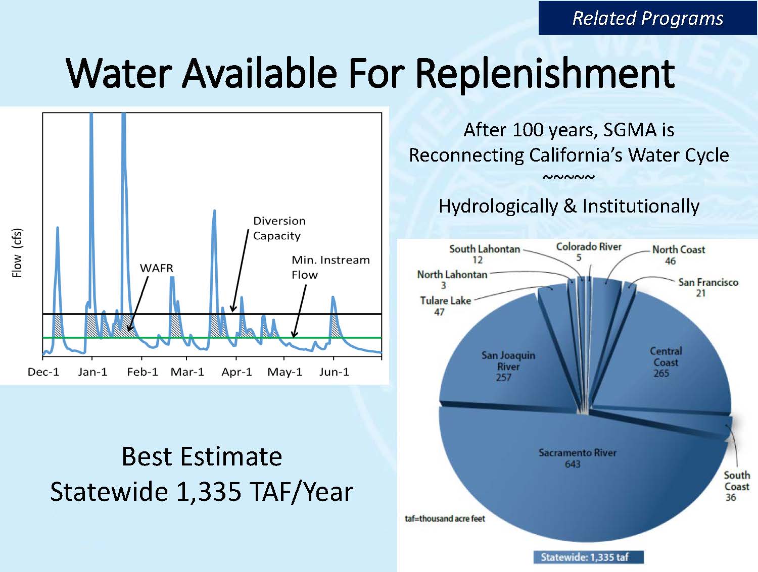 The passage of the Sustainable Groundwater Management Act has closed the loop on the state’s water cycle, Mr. Guivetchi said. As part of the legislation, the Department of Water Resources was directed to do a study to determine how much more surface water is there available for groundwater replenishment. He indicated that the final report is due out in October, and it basically found that on average, there may be 1.3MAF per year available for groundwater replenishment. But he pointed out that California is not a bathtub. “That water is available in different parts of the state and would only make sense for replenishment in a more local regional setting,” he said.
The hydrograph on the slide shows all the water during a water year that was available in various streams; he noted that the bottom line are the minimum instream flows, and the upper horizontal line indicates the maximum amount of water they felt could be available from an infrastructure and institutional setting. “Our current infrastructure and the current way that we manage water would not allow us to get water above that horizontal line,” he said. “So that range is what we call the best estimate; the 1.3 MAF is the average and that differs from year to year.”
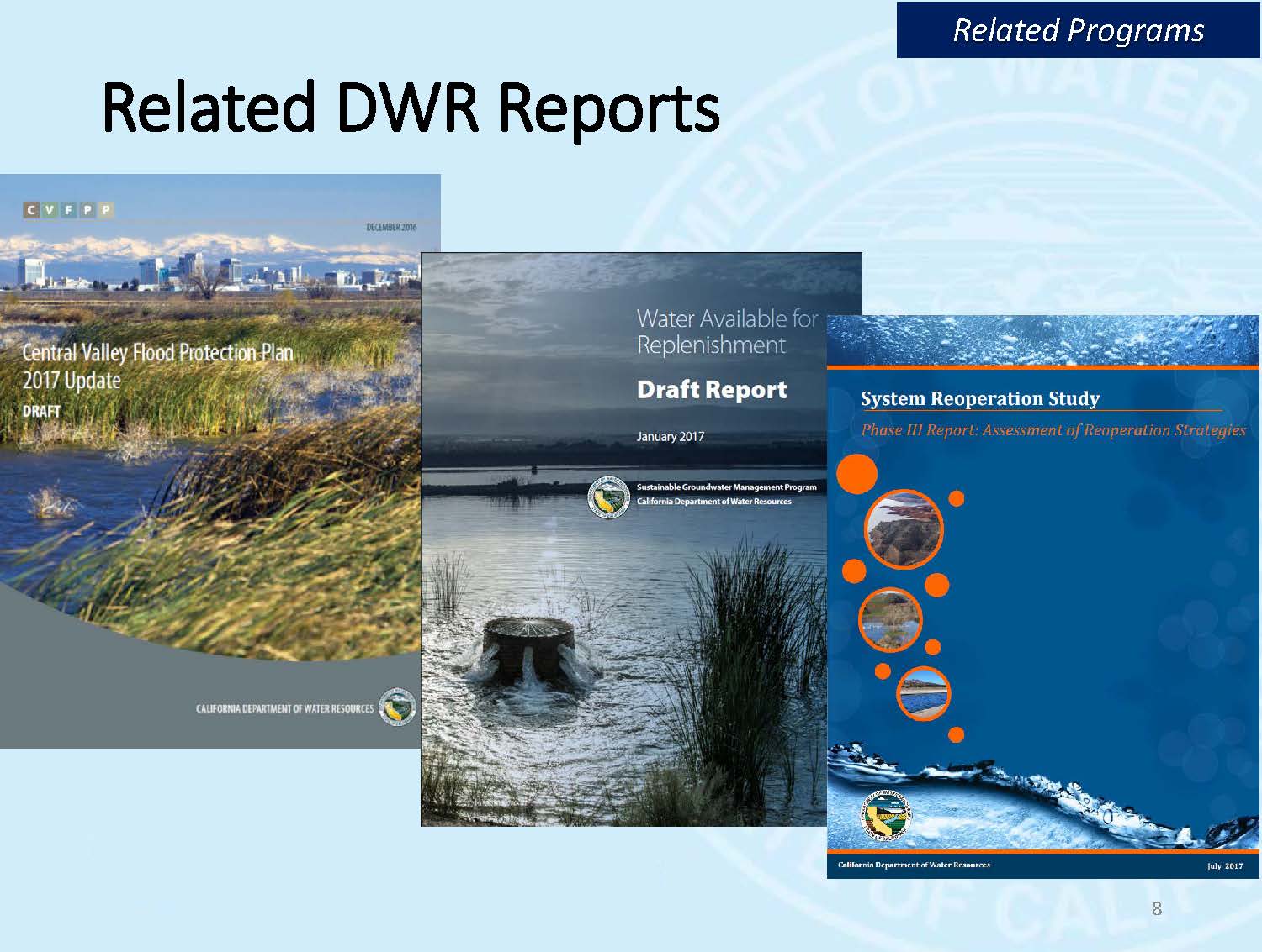 Three reports have come out in the last year or two: The Central Valley Flood Protection Plan, the Water Available for Replenishment Report, and Phase 3 of the System Reoperation Study. These reports all fit together, Mr. Givetchi said. “DWR was directed by the legislature and the Governor in 2008 to conduct the System Reoperation Study to see how much more could we get out of our existing water management infrastructure and the way that we manage water,” he said. “We were directed to do that by taking an integrated approach with flood management, water supply management, and water quality management concurrently while we try to optimize or see how much more we could wring out of our water management system.”
In the first phase of the System Reoperation Study, they looked at the building blocks of what they had to work with, and developed an engagement plan to work with facility operators. In the second phase, various types of reoperation strategies were developed, and in the third phase, they drilled down in more detail on some of them.
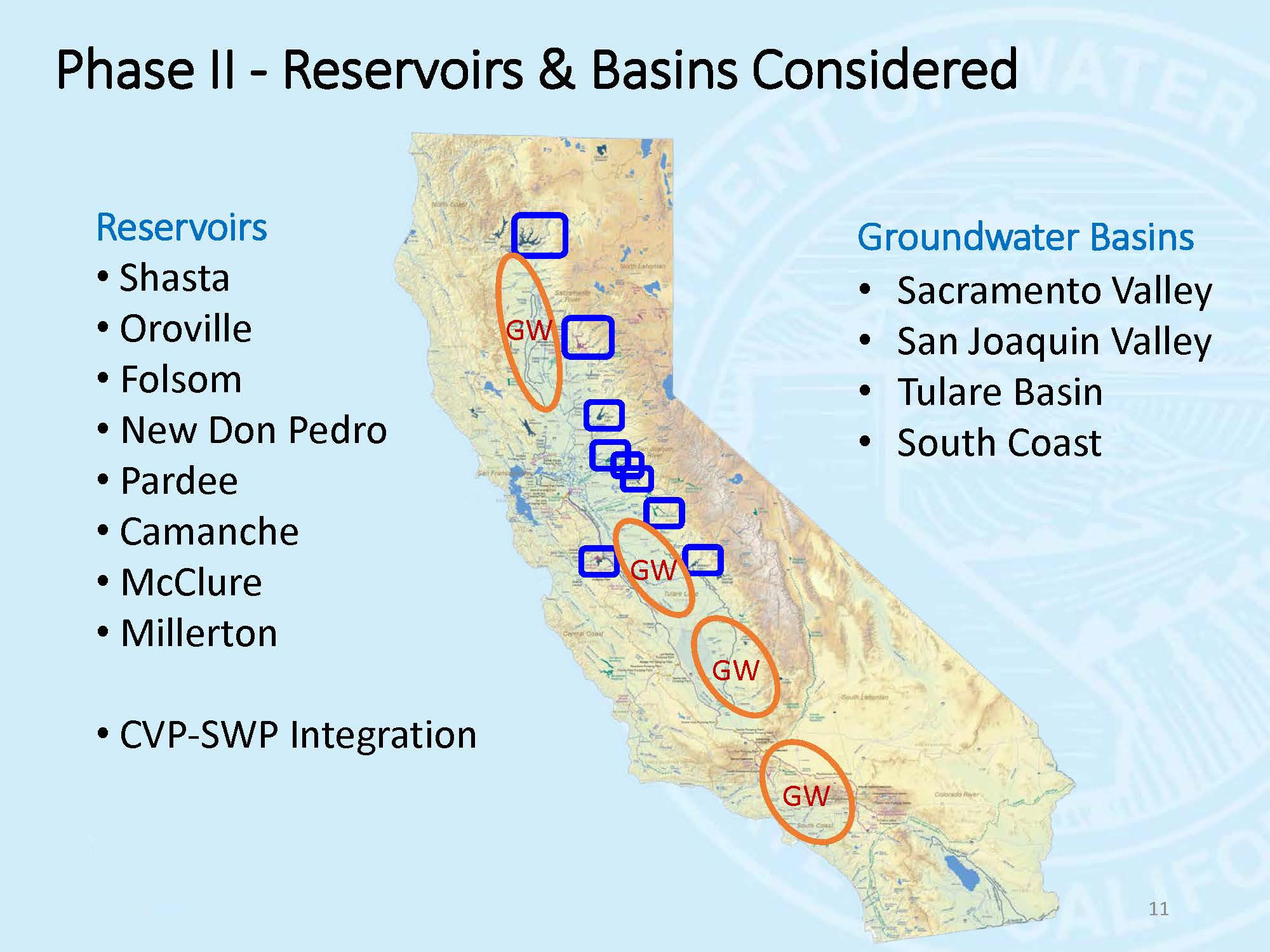 During the second phase of the reoperation study, they looked at different surface reservoirs and groundwater basins, both in the Sacramento and the San Joaquin Valley; they also considered what integrated operations of the Central Valley and State Water Project would look like as one project. “The first thing we did was go out and touch with the owners and operators of each of these facilities and groundwater basins, because one of our criteria was that we’ll include them in the study if and only if the operators wanted to be part of the study,” he said. “We weren’t going to have the state reoperating people’s facilities if that wasn’t something they had an interest in.”
They found groundwater districts were very enthusiastic because they saw this reoperation study as a potential source of replenishing the groundwater basins, but the reservoir operators, not so much. So for phase 2, they looked at Shasta, Oroville, and Lake McClure, both in combinations and individually. They looked at reoperation strategies, such as conjunctive management; providing supplemental flows, especially in the springtime for ecosystem management; and what could be gained by encroaching into the flood reserve space with what they call Forecast Based Operations, as well as considered the joint operation of the Central Valley and State Water Project by looking at shared storage and joint point of diversion. In phase 3, they did a more detailed study on these particular strategies.


“What we learned was that on the water supply side with conjunctive water management, supplemental flows, and forecast based operations in total, it gave us water supply benefits on average of about 37,000 acre-feet per year, ecosystem flows about 80,000 acre-feet per year, and then flood stage reduction about a tenth of a foot,” Mr. Guivetchi said. “On the joint operations of the federal and state water projects, we estimated that the two projects operated together could give about a 100 – 150,000 acre-feet more yield per year.”
 Mr. Guivetchi then gave the key findings of the phase 3 study. “The system is fairly optimized,” he said. “There’s not a lot more yield and flexibility that we can get out of the current infrastructure with the current operating rules. We also learned from the operators that our estimates of the potential improvements may be overstated because informally, they’ve actually been doing some of this stuff now and again, including Forecast Based Operation.”
The legislation also directed DWR to look at how the system reoperation improvements would be affected by new Delta conveyance and climate change hydrology. “We did that and what we resolved was in both cases with all those benefits, new conveyance in the Delta, about 9000 cfs more and 5 different climate change scenarios that we looked at, roughly the same ones that the Bay Delta Conservation Plan looked at, would not affect the results,” he said. “So the results are fairly resilient to both getting new Delta conveyance and new climate hydrology.”
The consideration for the third phase of the system reoperation study was to determine what would be the effect of new facilities, and after learning that ACWA had embarked on such a study, Mr. Guivetchi said that they decided instead to explore what it would take, infrastructure- and institutionally-wise, to begin tapping into those really high flood flows that currently they are not in a position or able to access.


This next phase of system reoperation will involve working with the Corps of Engineers and DWR’s Flood Management Division to adjust the operating rules on flood management, Mr. Guivetchi said. “This slide (above, right) shows that for the American River, looking at the last 30 years of historic hydrology and what’s predicted for 2070 through 2099, basically the last 30 years of this century, the dynamics of our hydrology is changing,” he said. “We get less runoff now in the January-February-March period and we have more snowpack and more runoff now in the May-June-July period when the water is being used, and that’s the way we plumbed our system. What the climate change hydrology analyses show is that’s going to begin to switch. We’re getting more snowmelt and less snow in the winter, so we have higher river flows and flashier flows in the January-February-March-April period, and in the summer, when we really need and use that water, we actually have less water available in the river, and so we want to begin exploring with the Corps and flood management on how we could change the operation rules to begin to reflect this trend.”
The Department of Water Resources is utilizing some of the funds allocated for the system reoperation study to develop a multi-sector engagement plan. “We’ve got to get our flood management community, our water supply management community, and our ecosystem management communities to work more closely together,” Mr. Guivetchi said. “As a tool to make that happen, we’re beginning work on a draft white paper that will explore the work that’s been done in the past, begin to frame what those opportunities and barriers are, and identify gaps in our information and our knowledge that we really need to fill to be able to realize or tap into this new opportunity of integrated water management. We’re also developing what we’re calling a plan of study that would be a multi-sector research and development plan that would be implemented in the next two to three years. This is an interdisciplinary plan that would engage agencies, academia, and NGOs, and we would look at studies as well as pilot projects to begin filling this knowledge gap.”


Mr. Guivetchi said they will be undertaking a multi-section initiative to get the funding, project management, and actual implementation of the study, the results of which will inform groundwater sustainability agencies, integrated regional management groups, and different agencies. “We’re going to be able to look at how do we need to realign our permitting and our regulations to be able to tap into these new opportunities, and then what will it cost to actually get the new infrastructure and the new systems needed, including data to help that decision making.”
DAVID BOLLAND
 David Bolland, Director of State Regulatory Relations with the Association of California Water Agencies, began by saying why ACWA undertook the study and what the study isn’t.
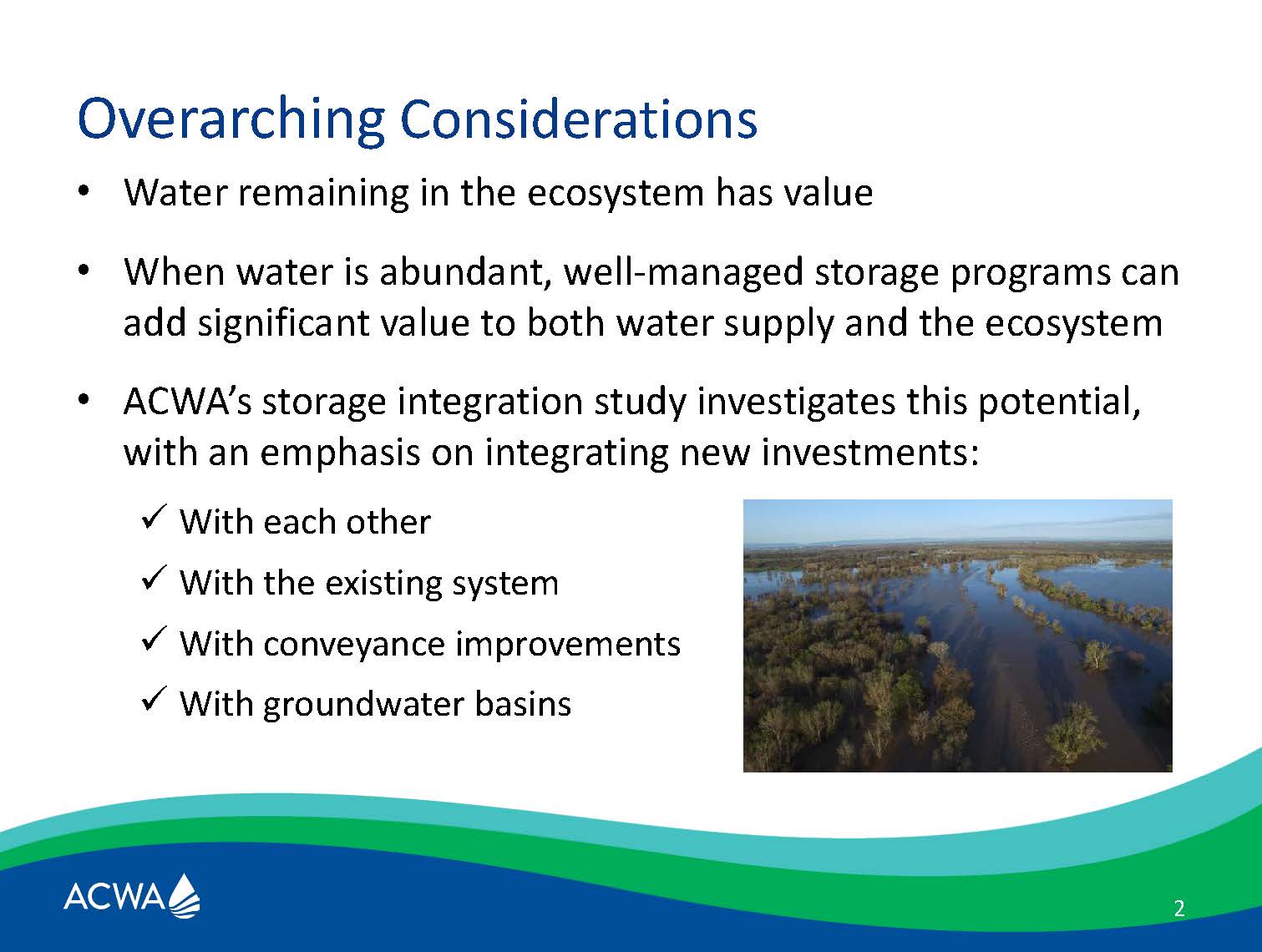
“What we’re not trying to do with this focus on infrastructure is we’re not trying to negate in anyway all of the other multiple objective approaches that are commonly used in water management,” he said. “We want to make sure that it’s understood that we see water in the ecosystem as having value and that we’re not trying to take water out of the ecosystem. We’re talking about using that water more effectively to meet ecosystem and as well as other needs in California, and then the fact that if we have water when it’s abundant and it’s well managed, we believe we can add value in terms of the way that it is managed, or in terms of its results and benefits. There is an idea that if we integrated that system, that more integration adds value to the system and that there’s opportunities there that we wanted to study.”
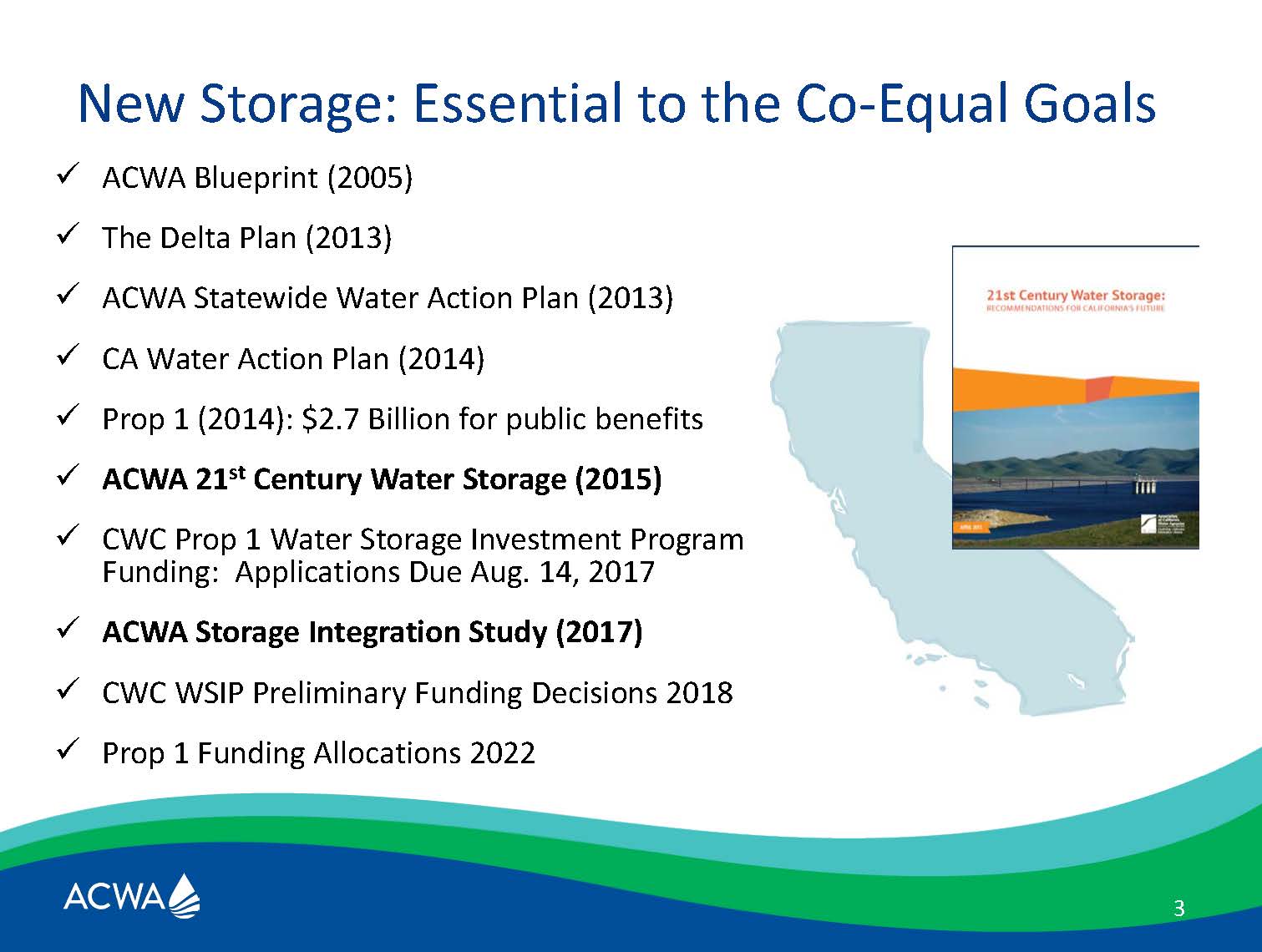 Mr. Bolland said that for more than a decade, ACWA released a blueprint intended to rally water agencies around a vision for multiple objective management. The Delta Plan adopted in 2013 reflected a lot fo that; the Statewide Water Action Plan that ACWA put out, they believe influenced the California Water Action Plan in a strong way. Then Prop 1 came along in 2014, as did SGMA, and a lot of things that kind of fit together in a policy framework; there’s $2.7 billion for public investments and storage. The Water Storage Investment Program’s regulations have been adopted, and applications are in the hopper right now.
Mr. Bolland said that ACWA and its members support a comprehensive approach to water management. “With making conservation as a way of life, the item that’s number one in the California Water Action Plan, the point we try to make time is that it’s not number one because we just have to keep doing it until we get it right and then go to number two; it’s number one because it’s important and it’s a presupposition,” he said. “There are a lot of other parts of the California Water Action Plan that are important as well … but we want to hone in on was storage, and just increasing the amount of storage available, surface and groundwater, and what would happen.”
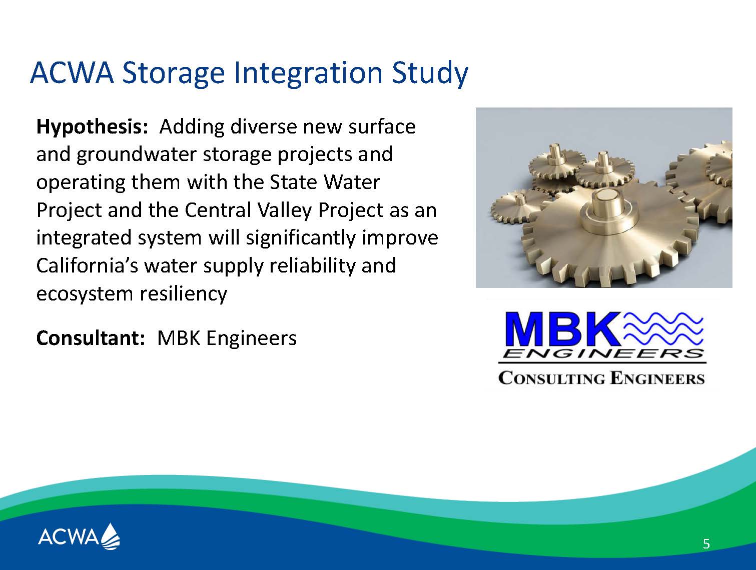 The hypothesis was that if infrastructure was added and the system operated in a much more integrated way, that the results would be that it would far outpace the value of the actual additional storage. “There has always been this conversation in the water community of what if you just were more efficient about how you used water in the existing system,” he said. “We want to continue to look at efficiencies in terms of administrative operation as well as infrastructure operation, and looking at the two systems as more of a single system now. … We can always do better, both administratively and infrastructure-wise, so we looked at what if we added some assets to the system, and we thought we would try to model that in a quantitative way because that hasn’t been done.”
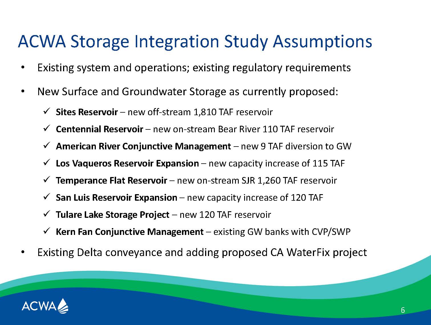 The study was performed by MBK Engineers; they used the suite of projects that many ACWA members were working on, many of which were anticipating applying for funding under the Water Storage Investment Program. “They all bring different kinds of assets to the table and different ideas, and so we took the conceptual stage of those projects that was available to us about a year and a half or so ago when we started this modeling exercise,” Mr. Bolland said, acknowledging that some project attributes may have changed a little bit since then. “We’re not taking those to the bank necessarily, that’s just what we used in our modeling. You will see that there are two projects there that didn’t actually apply in the end, but they still potentially helpful projects to look at ways in which you could use the water assets in different parts of the state to advantage.”
The study considered existing system and operations and existing regulatory conditions. Then the projects were added in their conceptual stage. The study considered with and without the California Water Fix project.
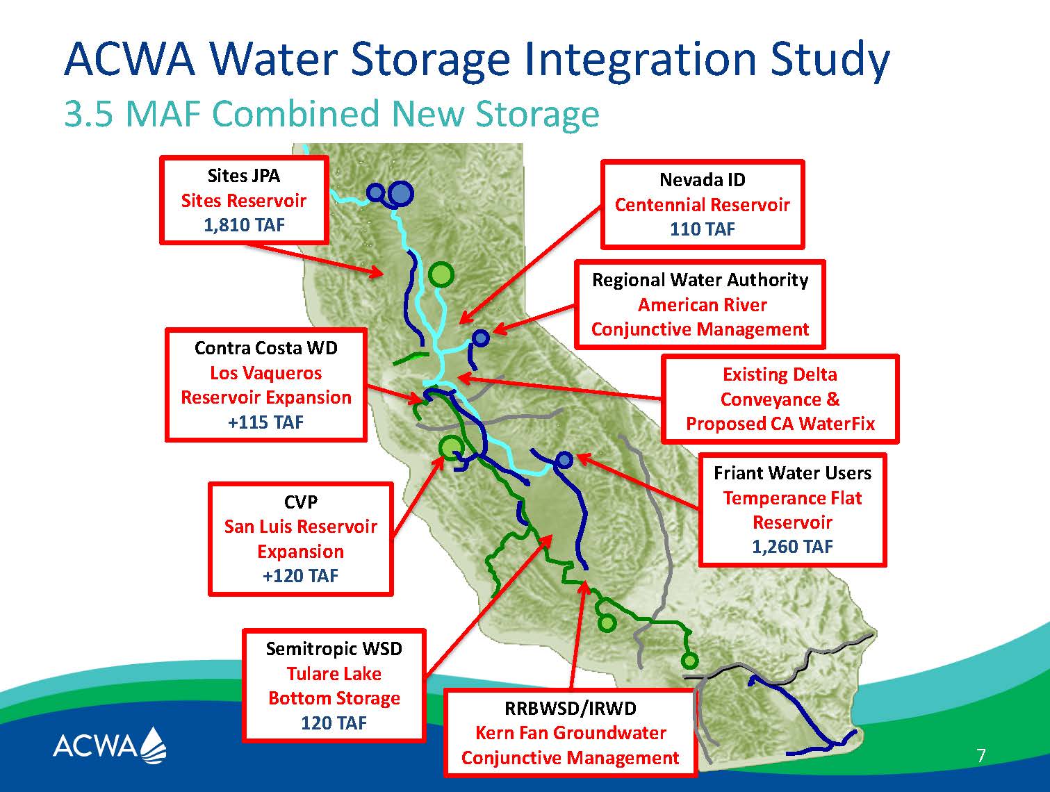 Mr. Bolland then presented a slide showing where the projects are located in the system, again acknowledging project attributes may have changed. “There’s a geographic element to this that’s extremely important,” he said. “We’re talking above the Delta, below the Delta, we’re talking about surface and groundwater storage, we’re talking about areas that are more coastal and areas that are more inland, and we’re talking about different kinds and sizes of projects. We wanted to use this portfolio of different kinds of projects to see what would happen and how we could operate those in a way that’s more efficient.”
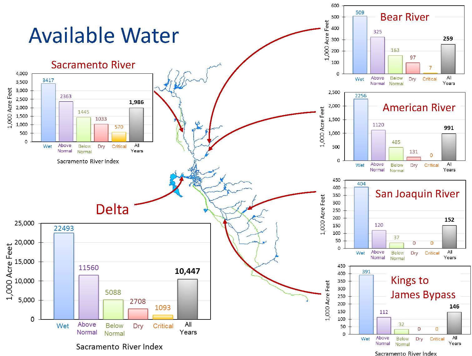 The study determined that the proposed storage projects would add a total asset of 3.5 MAF of combined storage, but they wanted to determine whether there was water in the system to put into these projects. “Obviously those projects themselves need to make that case on a more technical level and they are doing that, but what we did in our modeling was look at how the system works now in terms of hydrology, and the key message is variability,” he said. “It’s extremely important to realize that the way we’re going to find the water in the system is to look at flows in terms of timing, and so if you see, the years are classified as wet, all the way down to critically dry years, and then the averages. Averages are just a tool to convey information. In many ways, they are not helpful. You need to be looking at the ways in which the different water years perform. The geography is extremely important, and again, those arrowheads point to areas within the system where we thought there was water available, if it could be used strategically in storage and put into either surface or groundwater storage as an asset to the system.”
Mr. Bolland said they did find water in the system, and that’s an important point. “There have been those that have concluded there is no more water in California; we’re not making new water,” he said. “That’s true at a philosophical level and at a scientific level, the molecules are all fixed, but it’s about how we manage that asset. What we found is that there’s opportunity there. Again, the averages are dangerous to us to a point; the variability is the key thing to pick up here.”
The modeling period for the study was historical; they did not model for future climate change. Mr. Bolland noted that there are a lot of parallel efforts on characterizing the proper regime for climate modeling, so they decided they would tackle what is known about the historic hydrology as the premise for their particular exercise.


We need to link the water from where it is to where it could be and should be north and south of the Delta, he said. “In the dry and critically dry years is when, if we’ve moved it from those wet years into storage, that’s when it’s going to be felt most importantly,” he said. “That’s when the assets are extremely valuable – more valuable than normal.”
The study found about 10 MAF available in the Delta system. With the additional storage of about 3.5 MAF added to the system, this allows for more system flexibility in terms of timing and coordination. “The key focus that we had was on the idea of flexibility and using the system in a more flexible way if you have the infrastructure to do it,” he said. “In fact, we thought we could increase carryover storage up to 1.9 MAF, and that’s an important number. That carryover storage is the gold standard in terms of trying to operate our system.”


“The increased carryover storage would add to the reliability, the ecosystem benefits and the flexibility of the system, and in all water years, that’s important,” he said. “In the critical and dry years, even though it’s less water, that’s when it really matters most, and that’s an important finding.”
“The question has come up about how do existing water reservoirs work and how do our projects add to that, and so the line shows an existing amounts of water and what would happen if we took that water and put it in the system, how much water are we talking about taking,” he said. “In fact it’s a relatively small amount and that’s an important point.”
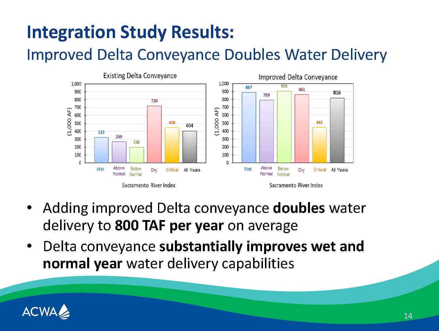 Mr. Bolland said that another important point is that with or without the Delta conveyance, the Water Fix, the results are striking. “In fact, we get significant benefits in dry and critically dry years under existing conveyance, but under improved Delta conveyance, we get extremely high, impressive, results – almost double the results under all different water years. That’s important because we need to be able to operate when we’ve got the assets and move those assets to where they can be used.”
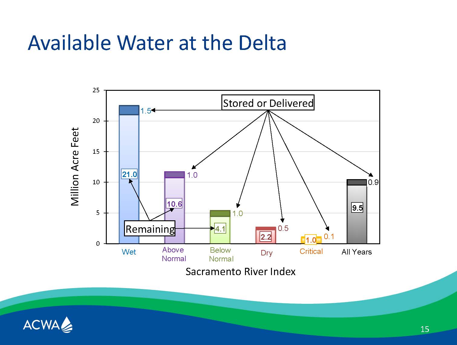 Mr. Bolland noted that the dark top of the bar chart shows the amount of water by volume that the study considered moving into storage. “The amount of water by volume that we’re talking about taking in each of those years into storage, compared to the amount that’s in the system, is a relatively small proportion in all years. Obviously, when you’ve got less water in the dry and critically dry years, when you take proportionally more, that has more concerning about how you manage that water, so we have flagged that as an important consideration and management is a key issue that has come up.”
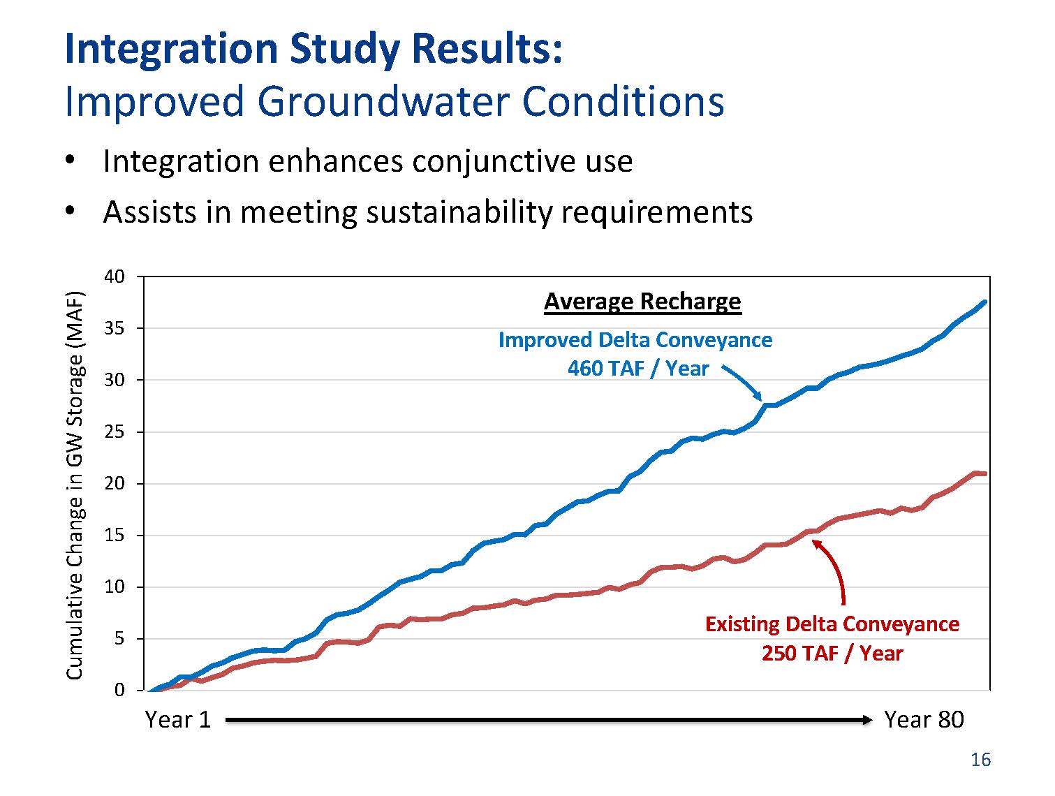 He then presented a graph showing how the additional storage projects could help in groundwater recharge. “Basically it’s like a bank account that you’re putting a little bit of water into every year and cumulatively, it’s an important amount of water,” he said. “With the existing system, we get about 250,000 acre-feet per year on average. Again, it’s not an average situation, but over that period, that accounts for a fair amount of water. That water can then be moved into groundwater storage; the way ran the model focused on moving it into the southern part of the San Joaquin Valley and trying to deal with overdraft there. So again, 250,000 acre-feet. It doesn’t solve the problem, it’s not a silver bullet, but it’s a significant down payment on the problem, and if you have conveyance, you double the amount of water that’s available.”
 He said there are several projects that could operate as a suite. “Many of the projects above the Delta could accentuate the ways in which we can use water in the Central Valley Project, particularly cold water fish flows is an important concept there,” he said. “Holding cold water, moving cold water around, using it more strategically, as well as meeting other beneficial use needs, and that’s the benefit of a suite of those projects in the northern part of the system.”
“When you look at the southern part of the system below the Delta, the idea there is you can opportunistically move water out of the system when you’ve got it, store it, and then put it back into groundwater storage when you need it, and that’s an extremely important value,” he continued. “You can also be moving water east and west across the system, and that’s important, and then also flow conditions in the Delta can also be enhanced.”
 “So the key conclusions were significant water is available, new storage increases our capabilities particularly for ecosystem management as well as for water supply and groundwater management, and we have a more resilient system that we can be using to adapt to climate change going forward, as well as all the other challenges that we face.”
DR. ROGER BALES
Dr. Roger Bales, Director of the Sierra Nevada Research Institute and Professor of the School of Engineering at UC Merced, then gave his comments on infrastructure and water data. He noted that his comments draws on work he’s done with a lot of collaborators. The Sierra Nevada Research Institute involves about 30 faculty at UC Merced. The UC Water Initiative is a multi-campus initiative within the University of California, and the National Foundation Critical Zone Observatory really applies to a lot of their work on new information systems in headwaters and understanding headwater hydrology.
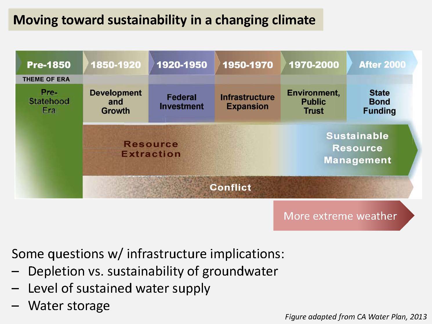 He presented a slide from the 2013 Water Plan, noting that it’s sort of a history of California around water issues. “As we try to move toward a period of sustainable resource management and reduced conflict, now we have one more arrow that we need to add that is affecting how we address these challenges, and that is the more extreme weather,” said Dr. Bales.
He noted that water storage is critical for the state’s water security, given the Mediterranean climate. “We have the most resilient water supply system of any Mediterranean climate in the world, and we probably need more resiliency added through that storage,” he said.
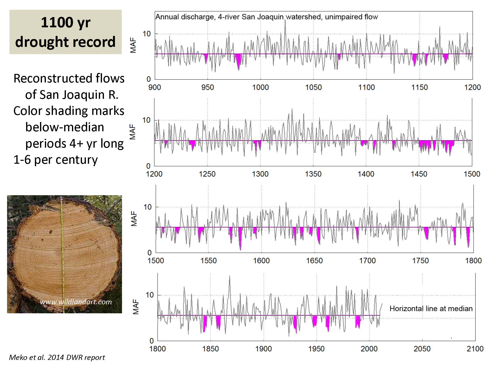 In terms of managing for extremes, Dr. Bales presented a graph taken from a report done for DWR. “If we look at the last 100 years, it’s just a reminder that we had a four year dry period recently,” he said. “There have been anywhere from 1 to 6 four-year dry periods every century, and this is just for the San Joaquin Basin; if you look after 1450 there, that’s a much longer dry period. We need resiliency that takes into account a little bit more than just the historical, less variable period that we’ve had. The other thing that is highlighted in the longer term record, there are a lot of dry years and a few really wet years, and those few really wet years are the ones we want to be able to take advantage of to get us through these long dry periods.”
He presented a graph of flood frequency, and posed the question, what is going to be the 100, 200, 500 year flood on our rivers going forward? “That’s not a question that we have answered yet,” he said. “How many 500-year floods has Houston had in the last 3 years? I think it’s 3. Individually and as a state, we maybe need a little more resiliency or flood insurance going forward, and I think there are some knowledge gaps around how we extrapolate out there.”


Storage is critical, he said, presenting a graphic from the California Roundtable on Water and Food Supply. “I want to emphasize two points. One, in a warming climate, storage will be even more valuable than it is now, and therefore it justifies investments a little beyond what we’ve made in the past on storage for the public benefit. And connections between the headwaters and the groundwater are essential as part of those investments.”
As Kamyar pointed out, snowpack is our largest storage reservoir overall, said Dr. Bales. “When you put the snowpack and the upper watershed subsurface storage together, the subsurface storage provides the base flow, it provides the water for vegetation during the dry season. When you put those two together, you’re roughly equal to all of the rim dams in the Sierra Nevada. We know that we didn’t have much snowpack and we also know that the upper watershed subsurface storage became depleted during the four year drought in many areas and the result was massive tree mortality. When the trees ran out of water, they no longer had the ability to continue to grow and to fend off pests.”
“So managing those, not just the rim dams with the aquifers but also the headwaters with the aquifers,” Dr. Bales. “Our green infrastructure as well as our gray infrastructure need to be co-managed together as storage becomes more important.”
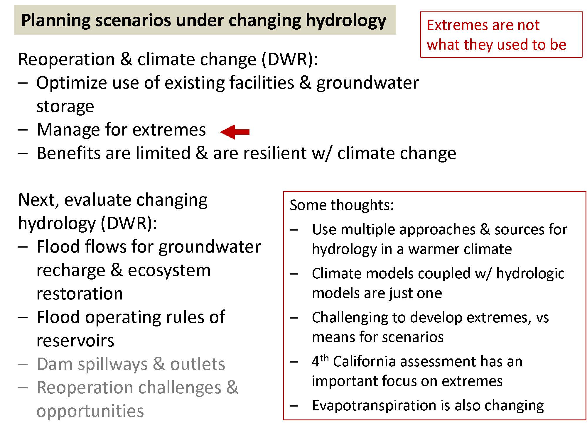 He then turned to planning scenarios under changing hydrology. “I agree completely with the first three points and optimizing use of existing facilities, and this is seeing that the benefits, although limited from the initial analysis, are resilient to climate change, but managing for extremes is the key point there,” he said. “Hopefully DWR will be moving ahead with that phase fairly soon on integrating the flood flows, that is the headwater and groundwater recharge systems and updating some of the hydrology under climate change scenarios.”
Dr. Bales then had some additional thoughts. The hydrology of a warmer climate tends to show flashier behavior in the future. “I just want to caution that using a few climate models to put together the extremes may not get us extreme enough,” he said. “We need to bring multiple datasets to these extremes. We’ve had more extremes outside the instrumental record of the 20th century and we can expect far more extremes going forward in a warmer climate. As the ocean heats up, we get more intense storms and so forth. So climate models coupled with hydrologic models are just one input that should be going into these. As these data become available, my hunch is on the storage, some of those storage options are going to become more valuable and some less valuable when you include climate scenarios in the analysis.”
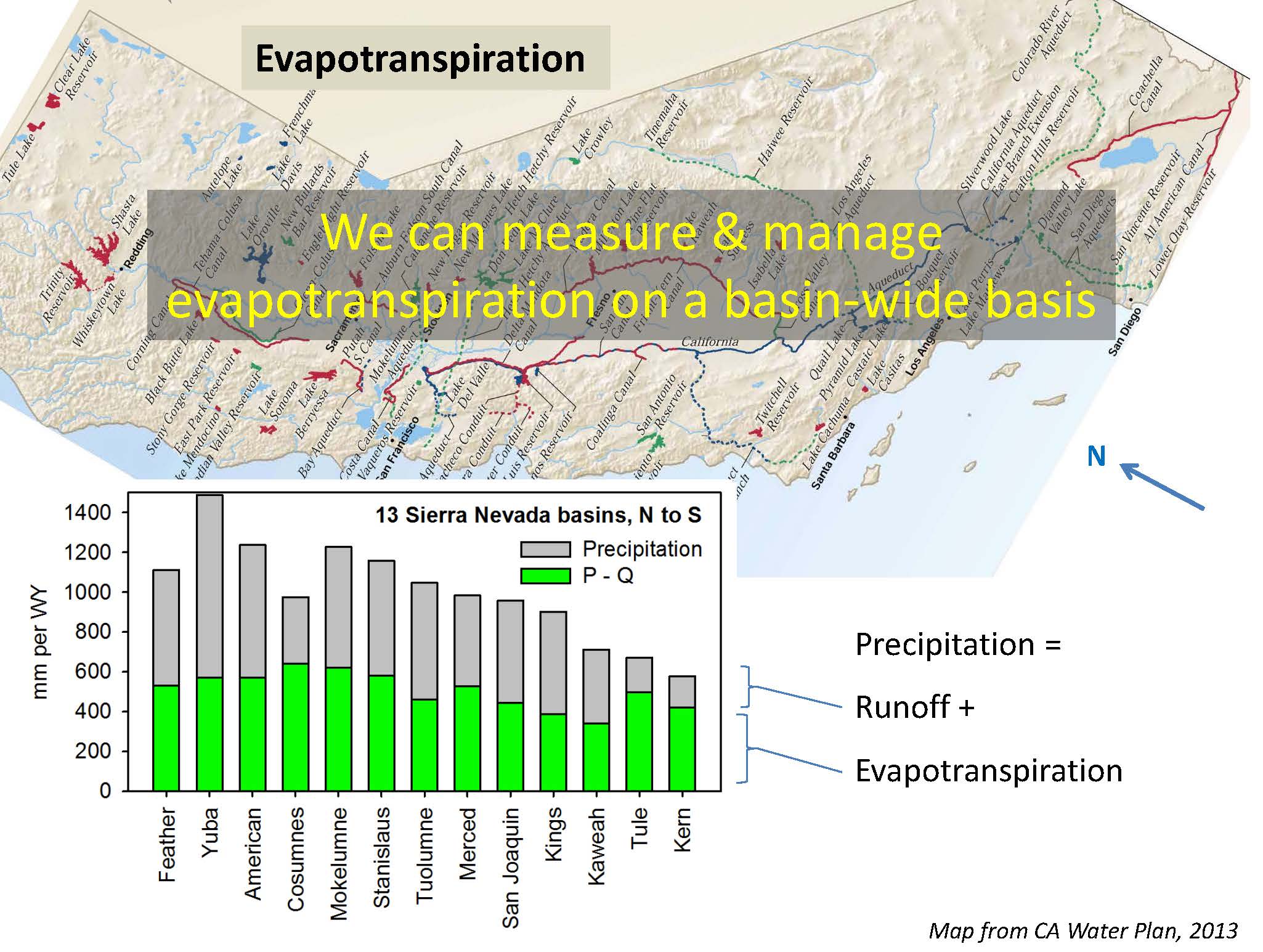 Dr. Bales said that evapotranspiration is also changing and that has implications for both reoperation and storage. “Evapotranspiration is changing for two reasons,” he said. “I’ve turned California on its side here, not necessarily so I can fit it on a graph but everything drains to San Francisco Bay to the Sierra Nevada that way. On the bar graph, I have the total precipitation on average which is the total height of the bar. The green shaded part below is the evapotranspiration, basically calculated as precipitation minus reconstructed flow at the rim dam. What you’ll notice is that evapotranspiration doesn’t vary that much across the Sierra Nevada. It’s more in the lower elevation basins because the growing season is longer for the forests. It’s smaller in the higher elevation basins like the Kings or Kaweah because there’s a shorter growing season for the forest.”
“Evapotranspiration doesn’t change that much from year to year, so we can change the precipitation, and the headwaters take their water first and the leftover is the groundwater,” he continued. “In a warmer climate, increased evapotranspiration due to longer growing seasons mean those green bars can go up. Of course, high intensity wildfires mean that the green bars go down, at least for awhile. I don’t want to get into too much discussion, but this is another factor that we need to consider in planning both storage and reoperation.”
Dr. Bales said that we can and need to manage evapotranspiration on a statewide basis. Evapotranspiration can occur in our headwaters or the agricultural areas or in our urban areas, so where do we want the evapotranspiration to occur? “On average, we have about 200 or 220 MAF of precipitation in California per year, and our water supply, which includes environmental flows and so forth, runoff from North Coast Rivers is about 80 MAF. So, much of the difference between those is that headwater water use, which is not going to be constant necessarily going forward.”
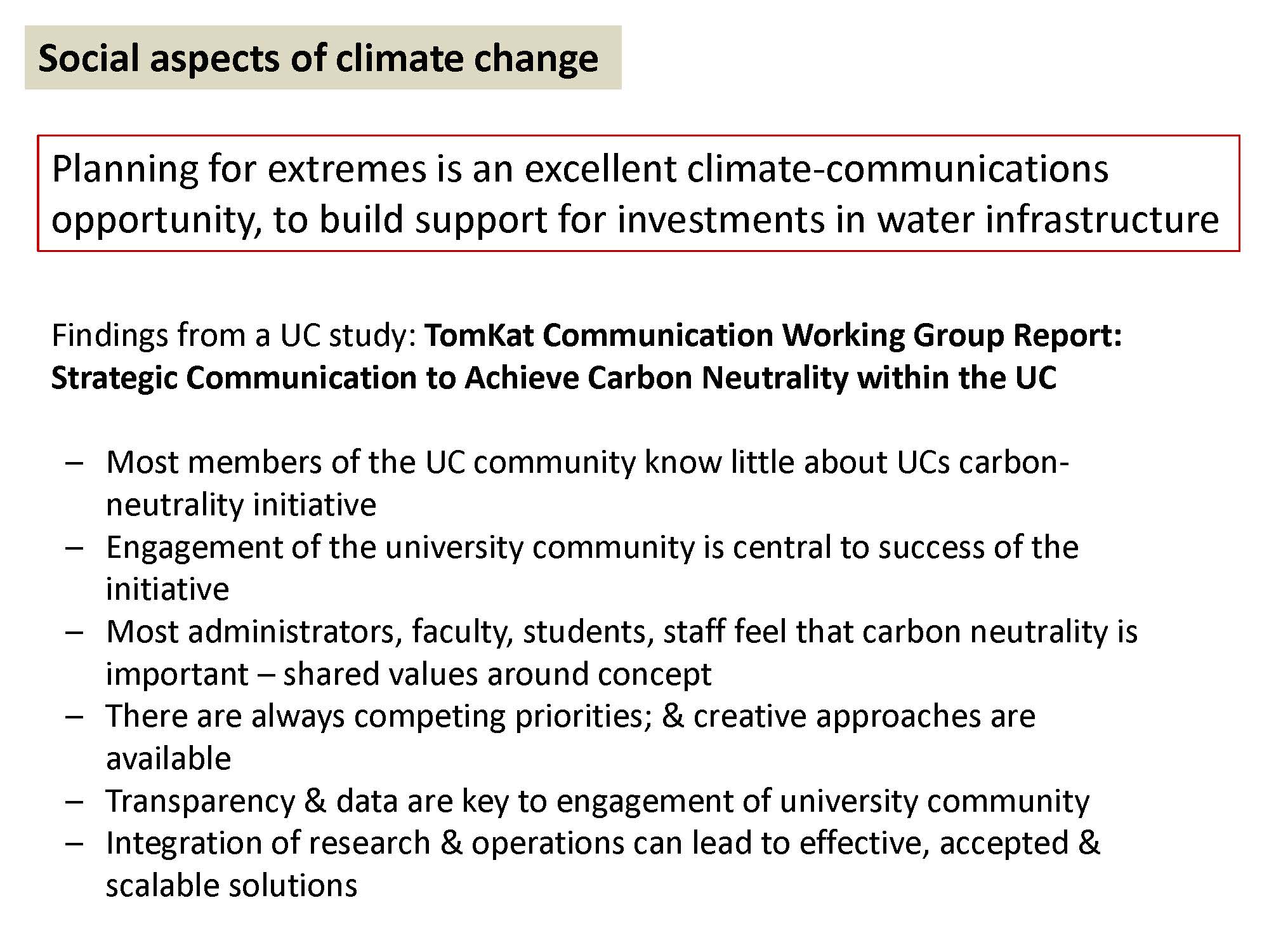 Dr. Bales said while we may have some technical solutions for climate change, we also need to focus on the social aspects, and planning for the extremes is an excellent opportunity for climate communications, both within state agencies and decision makers statewide. “I think a lot more can be done there,” he said. “We need to build support for investments in water infrastructure. We all know that it goes well beyond the four billion or so that was in the recent bill in the legislature. How do we get there? How do we build that support?”
Dr. Bales chairs a working group that’s been conducting an internal study at the University of California called Strategic Communication to Achieve Carbon Neutrality. The University of California has committed to become carbon neutral in campus operations by the year 2025, and they are not sure how they are going to get there. “We’re just as uncertain as the Governor on how the state’s going to meet the carbon neutrality and greenhouse gas emission reduction goals that we have,” he said.
The report is undergoing internal review before its release, but he gave a few of the findings. Most members of the UC community know little about the carbon neutrality initiative, and there are some parallels within organizations here in California in terms of measures to mitigate climate change and adapt what we can’t mitigate, he said.
“Engagement of the university community is central to meeting our goals, and I would say engagement with everybody within the Department of Water Resources, the State Water Resources Control Board, and other agencies is central to meeting some of the goals that have been talked about today,” he said. “Whereas in concept, most members of the university community feel that carbon neutrality is important as a concept; there’s competing priorities. We have some creative solutions we think on how to get around some of those competing priorities. There will be competing priorities when we consider how much infrastructure because of climate change versus lesser amounts. We found in our focus groups, interviews, and surveys that transparency and better data are key to engagement of our communities within the university.”
“Integration of research and operations through structured programs can lead to effective and accepted solutions that people will support and we feel are scalable,” he said. “I think there are some parallels there on communications and social aspects of climate change and how we need to focus on that, as well as the technical solutions.”
 Dr. Bales said that when he talks about water security for California or any place else, he talks about the three “I”s: Infrastructure, both green and gray; Institutions, stronger and adaptable institutions that is regional management, headwaters and groundwater together; and Information. “We can go beyond the early 20th century or mid 20th century information systems that we have,” he said. “There’s a lot of new technology; we can do better. And water security is the heart of our state’s adaptation to climate change.”
Dr. Bales recently wrote an op-ed with Michael Kiparsky on the need for better data and information to be connected to decisions. Their commentary noted that data and information are only as good as their usefulness for decisions and that we need to take the long view on climate and land-use change and think about what data we’re going to need in the future, he said. We need to do careful thinking on implementing AB 1755 and think long term and identify data gaps.
 “If you’re trying to allocate water during a drought, where’s the water rights database that gives you full information? It’s not there,” Dr. Bales said. “There are many examples like that. That one is one where maybe the data exists, and it just needs to be put into a usable format, but that requires an investment in information infrastructure. If you’re operating headwater hydropower dams or forest management or even rim dams, can you depend on the fairly sparse information system that’s out there in the mountains? Would knowing where the rain-snow transition was during the storms of this spring have helped operate Oroville Dam?”
He noted they are working with PG&E in the Feather River Basin to bring better estimates of water storage, snowpack, soil, precipitation as snow and rain, snow melt, runoff, and other data to bear on hydropower operations and other aspects of water operations.
“In closing, I just want to leave with the thought that a modern water information system, integrating the technology that’s been developed over the past ten years, low cost robust technology for enhancing ground based systems, blending with satellite data and occasional aircraft data – that really can take us into a new era of water information which is really to me the foundation for our water security and for our investments in both infrastructure and the investment needed to stimulate and grease the skids for better collaboration between institutions in the state.”
DISCUSSION PERIOD
Commissioner David Orth asked Kamyar Guivetchi how much regulatory support was he getting with his integrated planning process, and to David Bolland, he asked how regulatory influence was assessed in the integration study – did they look at the current baseline or did they try to project where things might go with the State Board’s water quality control planning process?
David Bolland answered first. “We used the current baseline and we just went ahead and assumed that going forward; we didn’t try to project any kind of changes to that. Specifically as it relates to decisions that are before the water board on flows and basin plans and so forth, we didn’t try to drop that in, but one thing I think that does come out is that that significantly affects the ability we have to operate the system. We essentially did a modeling exercise where we just built the baseline into the model, added the storage, and got the results. When we understand how that was done and our modelers are able to report out scenarios and why we got the results we got, it’s clear that the regulatory baseline does present a challenge for operations, and if we add to that challenge or do it in a way that’s one-dimensional and not integrated, we could basically have less value for those assets. In some ways, we didn’t try to presuppose how to use those assets, but clearly one answer would be, can you just dedicate more water to flows? Yes we could, but that means we can’t use it for other stuff, so the results of our study, we could talk a lot about scenarios with those, but it’s not built in other than just the baseline.”
“When we did the system reoperation study, we did pretty much use the current regulatory baseline, with the exception of the forecast based operation – we actually did tweak the Corps of Engineers rule curves as part of the strategy for forecast based operations,” said Kamyar Guivetchi. “The other thing that would be helpful for the Commissioners as you review our respective studies is as it turned out, the analytical approach and assumptions we used for the system reoperation study are essentially the same or very similar to what ACWA used, so they are comparable as far as how the new facilities that ACWA considered would affect the current system as we modeled it for the system reoperation study.”
Commissioner Orth asked Kamyar Guivetchi what level of engagement he had in his multi-sector work and study implementation effort. Where’s the State Board on this?
“A big part of this is communication,” Mr. Guivetchi said. “Again, we’re all working in our respective responsibilities and authorities that were set up siloed, so the fact that we have regulations that don’t jive and that may pull project proponents in different directions. That is a result of the fact that those regulations and the policies that underpin them were developed in silos, so as part of the California Water Plan since 2007, we have invited several other state agencies, including the Water Board, Fish and Wildlife, we actually have 30 state agencies, departments, boards, commissions on the state agency steering committee for the California Water Plan, and that’s to build those relationships … One of the five major themes or areas for the 2018 update to the Water Plan is regulatory alignment, so we recognize that to get to where we want to go taking an integrated approach, our policies, our plans, our regulations, our institutions are going to have to be much better aligned.”
“The white paper that I mentioned that we’re already beginning, DWR, we are already contacting other state agencies, academia, and others to begin using the white paper to help frame these issues and these opportunities because again, having a plan is not going to go anywhere if people don’t have ownership in implementing that plan,” continued Mr. Guivetchi. “So to me, the white paper and the plan of study are communication tools to begin to break down these silos and get people to recognize we can do the things we’re required to do in a more integrated way.”
Commissioner CHECK NAME asks Mr. Guivetchi, “You point out how the droughts are becoming more frequent and longer and that is affecting a number of different things. You mentioned the snowpack … is that with climate change appear to be declining as a storage opportunity. Did you calculate anywhere where that’s going to affect the water supply?”
“Scripps Institute has done that study,” answered Mr. Guivetchi. “We documented it in the 2013 water plan, and that is still seen as pretty relevant. Their study looked at snowpack through the end of this century, and they estimate by the end of this century, the total snowpack in California on average could be only 40% of what it is today. What we’re already measuring and observing is earlier snowmelt, so in the Water Plan in our climate studies documents, we document how the runoff pattern in the Sacramento River, the American River, other major rivers in California have already changed in what is considered the snowpack period, and the snow is melting sooner. Why that becomes important is the current Corps of Engineer rules are based on the historical pattern and so we’re not able to necessarily optimize that runoff pattern at this point. Now one of next phase studies that we want to do is work with the Corps, looking at climate change hydrologies to see how those rules could be better optimized.”
“The estimates are that most of that water will come down as rain, as precipitation,” Mr. Guivetchi continued. “What that does is it affects the runoff pattern, so unlike the snowpack that melts slowly into the late spring, early summer, with less snowpack and more rain, we’re going to get flashier systems, which makes replumbing and remanaging our floodwaters with our groundwater even that much more imperative.”
Commissioner ?: I would assume without additional storage, a certain portion of that would be lost.
“Now only would it be lost, it will be a significant flood risk, because our current flood infrastructure is not designed to manage some that additional flashy flows,” said Mr. Guivetchi. “That’s why this approach of taking some of the flood flows and putting it on agricultural and working lands on a volunteer basis, and some farmers are already looking for these opportunities to put that water on their land and use it as an opportunity to recharge their groundwater basins. While they are doing that, they are actually reducing the flood risk, in one of two ways: either by reducing the elevation of the floodstage and the river at that time or by allowing the flood reserve water to actually be put into the ground before that next storm comes, so you’re actually using the flood reserve space as water supply yield that could be banked in the ground. That goes back to the diversion capacity, so if you’re thinking now of conveyance facilities that would be needed to get it onto ag lands and other recharge basins, that increases your ability to divert these flood flows at the time that they are there.”
FOR MORE INFORMATION …
 Sign up for daily email service and you’ll never miss a post!
Sign up for daily emails and get all the Notebook’s aggregated and original water news content delivered to your email box by 9AM. Breaking news alerts, too. Sign me up!
